Confirmed hurricane and tropical storm threats hit both U.S.-watched basins in 2026, forcing real-world surge and rainfall warnings along the Gulf Coast.
Story Highlights
- Hurricane Isaias triggered storm-surge and hurricane warnings along parts of the Gulf Coast.
- Late-season Tropical Storm Pena formed in the Central Pacific with verified winds near 45–50 knots.
- Forecasters tied Pena’s setup to warm El Niño waters and a westward wind burst.
- Officials issued clear rainfall, wind, and surge guidance to protect life and property.
Verified Storm Activity In Two Basins
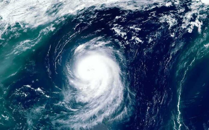
National Hurricane Center records show two notable 2026 tropical systems in different basins. Hurricane Isaias organized in early October and drew intense focus on the northern Gulf. Advisories began October 6, 2026, and continued as the storm strengthened and neared key shipping and refinery zones. The Central Pacific also saw named activity. The National Hurricane Center’s season table lists Tropical Storm Pena from November 6 to November 7 with sustained winds of 45 knots and a central pressure of 998 millibars.
Federal forecasters treated both threats as serious operational events. Isaias developed in the Atlantic and forced concrete planning along the Gulf Coast. Pena emerged late in the Central Pacific season, when storms are less common but not rare. Officials emphasized that each storm demanded attention because wind, rain, and surge can turn deadly fast. These records confirm that 2026 was not quiet, and that coastal communities still need clear alerts, strong infrastructure, and personal readiness.
Isaias Brought Gulf Coast Surge, Wind, And Flood Concerns
On October 8, the National Hurricane Center classified Isaias as a hurricane and issued hurricane and storm-surge warnings from the mouth of the Mississippi River toward Florida. The advisory warned of four to eight inches of rain with localized totals up to fifteen inches, plus life-threatening surge in warned areas. These numbers are not hype. They guide local leaders on evacuation, hospital prep, and power restoration staging. Clear warnings also help families plan fuel, food, and medicine before roads flood or bridges close.
Gulf communities know these calls well. Surge floods homes even when winds seem manageable. Heavy rain can arrive far from the center. The National Hurricane Center used plain language to explain timing and impacts so residents could act in time. That is the core mission conservatives expect from government in a crisis: accurate facts, fast alerts, and respect for local choice. Officials provided the data; families and small businesses used it to protect property and keep people safe.
Late-Season Central Pacific Storm Pena Confirmed
The Central Pacific storm list shows Pena as a named system on November 6–7 with 45-knot peak winds and a 998-millibar pressure, which is a solid tropical storm but not a hurricane. A forecast discussion linked Pena’s setup to very warm El Niño waters and a westward wind burst, both known to aid storm formation in that region. Later National Oceanic and Atmospheric Administration material and advisories cited winds near 50 knots and pressure around 998 millibars, reinforcing the measured strength of the system.
These details matter for planning in Hawaii and the broader Central Pacific. Even a mid-strength tropical storm can snap power poles, flood low spots, and stall supply chains. Cargo routes, emergency managers, and base commanders all track those wind and pressure numbers. The record confirms that the Central Pacific did not escape 2026’s tropical weather. While Pena was brief and did not become a major hurricane, it was real, measured, and operationally relevant to the region’s safety posture.
Short-Term Drivers Versus Long-Term Context
El Niño can tilt the odds for storm formation and track in the Central Pacific. Scientists also study how a warmer baseline might change rainfall or rapid strengthening. The formal way to sort those roles is an event-attribution study that compares today’s climate to a model world without human-added greenhouse gases. Such studies test changes in odds or intensity for a defined event, not whether climate “caused” a single storm. The current official records confirm the storms and impacts but do not quantify each driver’s share.
Severe Tropical Storm Cempaka has intensified into a typhoon but remains outside the Philippine Area of Responsibility, 1,630 kilometers east of extreme Northern Luzon, according to state weather bureau PAGASA on Sunday afternoon (Nov. 8, 2026). | via Charm Carcueva; 📸 DOST… pic.twitter.com/bncnUwNPFI
— Philippine News Agency (@pnagovph) November 8, 2026
For readers who want straight talk and solid ground, here is the bottom line. The United States faced a real Gulf Coast hurricane scenario in 2026, and the Central Pacific logged a verified late-season storm. Federal warnings focused on surge, wind, and rain so families could act. That is proper government service: inform the people, do not lecture them. Keep personal responsibility front and center, and back it with clear data, not slogans. That approach helps save lives and respects freedom.